- Joined
- Jul 13, 2015
- Messages
- 15,013
- Location
- Somewhere Nice Not Nice
- Gender
- Male
- Religious Affiliation
- Christian
- Marital Status
- Married
- Acceptance of the Trinity & Nicene Creed
- Yes
.
The Space program started in earnest in the early 60's. CGI didn't exist at all until the 90's and even then CGI looked faked. Star Wars in 1977 was the first movie that didn't look like spaceships were hanging from a string (just look at the original Star Trek and Lost in Space TV shows). Even then, the original Star Wars trilogy didn't use CGI and it still looked fake.
Elon Musk sells a product to bot the government and private companies. That product is placing satellites in earth orbit for a variety of reasons. Elon Musk wants to make money and if his product is fake/doesn't work then he will not make money. He is also making money off starlink, the satellite based internet service. Which he would not have been able to implement if satellites weren't real.
My experience with Flat Earthers is they see what they want to see. Any picture/video of an optical illusion that makes the earth look flat is real and any picture/video that shows a curved planet is CGI.
They come up with arguments that don't take into account basic physics, known natural optical illusions, how ships and planes navigate on a curved earth (if the earth was flat then all these ships captains and pilots would get lost because they have taken into account the curve of the earth since global travel became a thing), and just says things that exist don't exist. For instance, the insistence that there are no direct flights over the Southern Hemisphere. Or that it is illegal for civilians to go to Antarctica.
Trying to "debunk" Flat Earthers is pointless, there is no amount of debunking that will prove to them that their belief is false. Short of sticking them in a rocket and launching them into space so they can see for themselves, they will not believe.
Sadly, there are bunch of "Flat Earth" preachers who are making a lot of money from people watching Youtube videos, speaking at Flat Earth conferences, and selling flat earth merchandise. My guess is most of those "preachers" are just using gullible people to make a living.
I work in I.T. and have built computer networks for almost 30 years. Satellites are real. Also, when you put point to point microwave transmitters on towers and you have to adjust for the curve of the earth. It is part of the equation when planning microwave networks.You are probably unaware that nearly all internet uses undersea cables to hook up servers across nations. Don't take my word for it, look it up.
The Antarctic treaty doesn't prevent anyone from traveling to Antarctica. If you have the money and the time you are more than welcome to go walk with the Penguins.Oh, so I guess you don't know about the Antarctic Treaty eh?
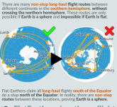
That is not true. There are flights (at least there were pre-pandemic) that went South from Buenos Aires and Santiago to Sydney and Auckland. Those flights are 9-12 hours. Can you produce a flat earth map where you can make that flight in 12 hours and never leave the Southern Hemisphere?Be it by sea or air, all circumvention is east to west or west to east.

Eh, the first statement doesn't qualify the other. I don't care what you claim to be. But you should, as an IT person, be aware that much internet communications take place with underwater cables.I work in I.T. and have built computer networks for almost 30 years. Satellites are real.
Also, when you put point to point microwave transmitters on towers and you have to adjust for the curve of the earth. It is part of the equation when planning microwave networks.
How to cruise ships get internet? The answer, when they are close to shore they use cell signals. When they get far enough away from shore that cell will not work they use Satellites.
You can't send data on analog short-wave radio signals. At least not at the speeds needed to service the crew and passengers of ship. There are a couple of companies trying to develop short wave internet transmissions but so far they have had very limited success.
The Antarctic treaty doesn't prevent anyone from traveling to Antarctica. If you have the money and the time you are more than welcome to go walk with the Penguins.
That is not true. There are flights (at least there were pre-pandemic) that went South from Buenos Aires and Santiago to Sydney and Auckland. Those flights are 9-12 hours. Can you produce a flat earth map where you can make that flight in 12 hours and never leave the Southern Hemisphere?
View attachment 1861
First, Satellites are expensive to launch and maintain. In the mid-2010's companies were looking for ways to bring internet to rural/remote areas. Project Loon was one of several projects exploring ways to make the internet more accessible. It didn't work and was shut down. When SpaceX demonstrated that they could provide rural areas high speed internet via private satellites that were cheaper to launch and maintain then most of the other projects shut down. Including the testing of using power lines to supply internet services.You are more likely adjusting for the bouncing of whatever signals is being sent/received off the ionosphere. Hate to break it to you, but world wide communications predate so called "satellites".
Btw, you ever heard of project loon? Loon LLC - Wikipedia
Please enlighten me why this is even REMOTELY NECESSARY if satellites can just beam info to any area on earth.
Primitive tech was capable of transmitting voice and teletype using a combination of analog telephone and radio signals. The amount of data was miniscule. Today, you can be sitting in a ship in the middle of the Atlantic and save and access megabytes of data. And while it is true that Fiber is ran all over the world, but Fiber can't be everywhere. Satellite internet is still not near as fast as Fiber, but it is much faster than it was even five years ago.Or more primitive tech used during the first world wars
I would like to see a source for this. An official source and not just some flat earther claiming this is the case.No ordinary citizen can legally go beyond certain points in Antarctica.
Unless you can show how you can get from Austrailia to South American in 9-12 hours without having to cross the equator on a flat earth then it is a valid point.This is a straw man argument.
You've obviously never had to setup DirectTV. You have to have a clear path to a certain point in the sky and then you have to adjust the dish to point to the satellite. And please don't try and tell me it was a balloon. A balloon would never be able to remain still enough for communications. Winds and weather would toss a balloon around like a tennis ball.Since satellites is a topic under the topic of discussion, here's some more info for anyone interested:
Satellites Don’t Exist
Discusses land based communications in operation since WW2 (example: LORAN), the connection between sci-fi dreamer Arthur C. Clark-2001, a Space Odyssey an Stanly Kubric (director for movie and "moon landings") - and a host of communication technologies that are all designed to work for communications WITHIN OUR ATMOSPHERE.
I would like to see a source for this. An official source and not just some flat earther claiming this is the case.
Everything I've read says you can take a boat to Antarctica, take some beef jerky and a tent and go anywhere except a few scientific research facilities. Kinda like what his guy did.
Unless you can show how you can get from Austrailia to South American in 9-12 hours without having to cross the equator on a flat earth then it is a valid point.
You've obviously never had to setup DirectTV. You have to have a clear path to a certain point in the sky and then you have to adjust the dish to point to the satellite. And please don't try and tell me it was a balloon. A balloon would never be able to remain still enough for communications. Winds and weather would toss a balloon around like a tennis ball.
I want to know what earth model you do subscribe to that would allow the Travel from Australia to South American in the Southern Hemisphere in 9-12 hours. I don't care if it is pizza shaped or not.Dude, I already told you I don't subscribe to the AE (pizza shaped) flat earth model
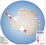
I said that there are scientific research facilities that you can't go into. Which is all that article references.Wikipedia is not an official source, however it does list official sources for reference points. Basically, anything south of 60 latitude requires a permit. Here ya go: Antarctic Specially Protected Area - Wikipedia
I want to know what earth model you do subscribe to that would allow the Travel from Australia to South American in the Southern Hemisphere in 9-12 hours. I don't care if it is pizza shaped or not.
I said that there are scientific research facilities that you can't go into. Which is all that article references.
My point is, on a flat earth, no matter what "map" you use it is impossible for those flights to happen. I don't know if you can book a flight now due to Covid, They were expensive Direct flights from Qantas airlines back before the Pandemic.I never made any claim about time to and from these destinations. I have no idea how long it takes. I just took a quick gander at flight times and see most with 2 stops are way upwards of 20hours...so not sure what your point is?
Not according to this map. The ASPA area takes up a fraction of Antarctica.A whole bunch. That's EVERYTHING south of 60 degrees latitude. No one, absolutely no one, without a special permit, can step south of 60 degrees latitude. Because why? Is it a magical area down there or something?

I'm doing some research on his page. His main problem is that he links this page as a source.You very obviously didn't read anything on that page. Sheesh.
?My point is, on a flat earth, no matter what "map" you use it is impossible for those flights to happen. I don't know if you can book a flight now due to Covid, They were expensive Direct flights from Qantas airlines back before the Pandemic.
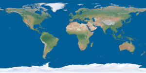
I'm not referencing any map. I'm asking what your map looks like. How does it account for air travel, navigation, timezones, lattitude and longitude, tides, and so forth? How far apart are the countries? Where is Antarctica and how big is it? It is an ice wall like most flat earthers say?So stop referencing it, please.
Not any more strange than I have to have a passport and entry visa (Permission) to go to the UK or France or Germany. It is a big, dangerous, desolate place. It would be pretty stupid to go without someone showing you how to not die. Although it you want to take a boat and sneak on to the continent I doubt they have border patrol. Go for it.Do you think it not a bit strange that both Antarctica and the North Arctic are governed by treaties where no one can go exploring on their own without a special permit that is unlikely to be granted outside of the hand-holding guided tours provided?
I'm not referencing any map. I'm asking what your map looks like. How does it account for air travel, navigation, timezones, lattitude and longitude, tides, and so forth? How far apart are the countries? Where is Antarctica and how big is it? It is an ice wall like most flat earthers say?
Not any more strange than I have to have a passport and entry visa (Permission) to go to the UK or France or Germany. It is a big, dangerous, desolate place. It would be pretty stupid to go without someone showing you how to not die. Although it you want to take a boat and sneak on to the continent I doubt they have border patrol. Go for it.
If Antarctica is an Ice Wall then how do you explain this?
Or this?
So you are saying the earth is a flat square or rectangle and it is some kind of miracle that you can go from East to West without having to come to an "edge"At present, I'm not dogmatic about a map. However if pressed, I'd say the most probable one is a rectangular/square map similar to what one sees on the flightradar site I linked earlier. Obviously, there is no circle on this kind of map to show E-W and W-E circumnavigation. Therefore, it has an extra-ordinary quality about it, where the end of E intersects the beginning of W and vice versa.

That, by itself, means nothing. It doesn't mean the all the countries are lying about Antarctica. If all the countries are keeping this big vast secret then that would be extraordinary. Somebody, somewhere would get ticked off and "spill the beans".Basically, if it's not a sanctioned tour, you can forget it.
